I woke up with frost on the
inside of the tent, and on my down jacket and rucksack. Bed tea was at
the (almost) reasonable hour of 06.00, and we got going at 07.44 after
a breakfast of creamed rice, toast and omelette. We headed back down
on, and between, the moraines of the Imja valley with lots of dust in
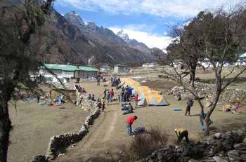
the air as the wind got up. We hit the first, and largest, civilisation
we had seen for some time at Chhukhung, a village that was largely a
series of lodges for trekkers - a pattern that was repeated down the
trail. The village was located just beyond the end of the Lhotse
glacier, which hardly looked like one, although a little ice showed
under the piles of rubble.
|
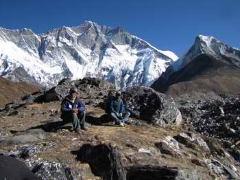
Two of our sherpas resting, with Lhotse and Island Peak
in the background
|
|
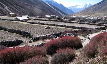
Stone-walled fields above Dingpoche
|
|
As we descended the valley
shrubs began to appear, mainly the deep red autumn leaves of berberis.
Just before mid-day we reached Dingpoche with its rectangular
stone-walled fields in which potatoes mainly are grown. We came across
a series of solar kettles - the pot being suspended at the focus of a
parabolic mirror. Our cooks prepared lunch for us, however, on the
usual large primus stoves in one of the lodges in Dingpoche, and once
again managed to produce chips!
|
After lunch we had a short
walk down to our overnight stop at Orsho, past a number of farms
located down on river terraces, each of which took the form of one
stone building surrounded by stone-walled fields on a patch of level
ground. Many of the fields were tilled, and presumably had potatoes in
them. Other fields were used as pasture. There were pancakes of dung
spread out to dry in places. On one of these farms we saw a woman
feeding yak or dzo calves, and a yak feeding her calf.
By now we had joined the main Everest trail, so the amount of human and
packhorse and yak traffic was consequently higher.
|
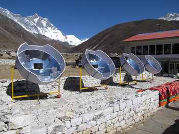
Solar kettles in a trekker's lodge in Dingpoche
|
|
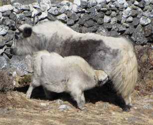
Mealtime for a little yak
|
|
We camped in the field behind a
lodge, and ate in the draughty dining room annexe - the door didn't
shut properly and it seemed very chilly when the sun went down. However
there was no frost, so it must have been a warm night. Standing by the
wall at the back of the lodge, and holding my mobile up in the air, I
manage to get a signal and send texts back home to say I was still
alive and kicking.
It was Geoff's birthday, and somehow or another Biri had cooked, and
iced, a delicious cake. There were even candles!
|
Monday 2 November
|
|
|
We set off down the valley at
07.40 - down the valley meant that actually we were alternately
climbing up and descending down over ridges. We spotted the first real
green vegetation at an altitude of about 4,000m, although the majority
was still dried up. Some colour came from the re-appearance of blue
gentians. On the other side of the valley the woodland was leafless,
but was given a ghostly appearance by the lichens handing from the
branches. The trail was spectacular in places, clinging to the steep
hillside.
|
We stopped in the village of
Pangpoche, a scattered village with stone-walled fields and many stone
buildings and lodges. Here we visited the 604 year-old monastery, we
trekkers being tourists, and the sherpas devoutly bowing and kneeling.
Continuing on we could see the larger, and newer, monastery of
Tengpoche across the river.
After this there was more up and down until we walked around the spur
of a hill and had an aerial view of our sirdar, Panuru's (and
most of the sherpas') village of Phortse. The cook-boys climbed up the
hill to welcome us with hot orange squash before we dropped down
through the stone walls to Panuru's guest house garden, where we camped.
|
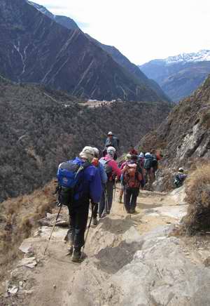
On the trail to Phortse; Tengpoche on ridge in middle
distance
|
|
Camp site in Panuru's field, Phortse
|
|
After lunch we were taken on a
guided tour of the village. First stop was the school, which had been
set up with funds from a UK charity headed by a friend of George, Tony
Freak (Papa Tony). There was a new library which had only been open two
weeks and was entirely stocked with English books. Then we had a tour
of the classrooms; the children, in three classrooms, were supposed to
be busy copying stuff down as decreed by the single teacher, but of
course were far more interested in us and our cameras. George gave a
short speech and gave a donation on our behalf to the school and the
adjacent clinic.
|
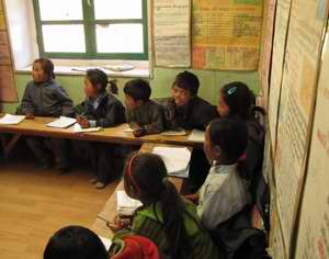
Maths class in Phortse school
|
|
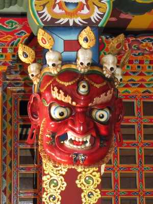
Mask in Phortse Monastery
|
|
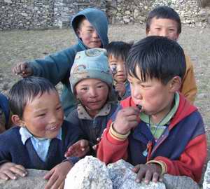
Children's welcoming committee in Phortse
|
|
After the school we walked up
the hill to the monastery, also built with UK funds and recently
decorated inside. Another donation was given here. The Llama, Panuru's
father, presented us all with silk scarves.
Back at the camp-site it was tea-time, taken in the lodge lounge where
a fire had been lit in the stove as it began to cool outside. It was at
this point I chose to have a shower. Panuru emptied a bowl of hot water
into a receptacle and send me down to the shower cubicle outside on the
floor below. Apart from the first rush of icy water, and the low
ambient air temperature, this was a delightful hot shower.
Dinner was a cosy affair, as the stove was on full blast, and dinner
somehow tasted better - roast potatoes, rice, spinach, dhal sauce and
chicken, followed (again) by warm tinned fruit salad. The room was full
as several people (including a couple of Russians and Belgians) were
staying in the lodge.
|
Back to top
|
|
Back to
previous log
|
Next log
|