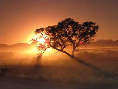
Sunrise at Sesriem, waiting for the park gates to open |
Inside the park we were rewarded with great views of the sinuous ridges of the dunes, highlighted by the contrast between the red sand and the shade due to the low sun. It was also cool at first. As we headed west along the floodplain between the dune areas a hot air balloon was skimming slowly over the grassland on the far side of the dry river bed.
About 60 km into the park we stopped at the '2x4' parking area, graced with some long-drop toilets, & gents urinals made of plastic tubes stuck in the ground! Chantel & Todd let down the tyres of the vehicles a little for the next 5 km stretch over loose sand to the 4x4 parking area, and start of the walk to view the Dead Vlei - where the river used to end & drain into the sand, but which has been cut off by the encroaching dunes.
By the time we had photographed the dead trees enough the temperature had risen markedly - so when we drove back, with tyres re-inflated, to climb 'Dune 45' - the iconic picture dune - only five of us decided to climb to the top. We were rewarded by a great view of the contrast between the red dunes and the pale fawn colour of the dried grass of the floodplain.
After lunch at the Oasis store & petrol station at the park entrance (temp = 41C), we visited the Sesriem Canyon - a narrow cleft in loose conglomerate rock. There was still water in the upper part of the canyon, which floods to a great depth during the rainy season in the mountains. Recent years have had record rains, and grasses have grown as a result where they didn't exist before.
Then it was back to the lodge, the milky pool and, for some, a close encounter with some rescued 'cats'. A fascinating day!
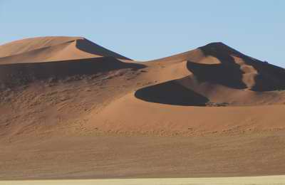
Dunes in the Namib
Desert
|
Saturday 22 October
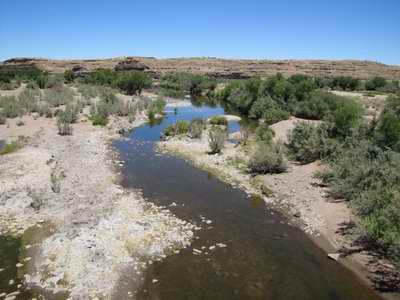 |
Fish River from the Fish River Bridge |
Another travel day, only this time with over 500 km to cover. So another early start - on the road by 07.30 and heading up the road to the Tsaris Pass to reach the Central Plateau - a vast open expanse of flat, dry land over 1200 m. There was dry grass and scrub, and the occasional artificial water-hole. We turned south before Maltahohe and continued beneath the Schwarzrand escarpment - a 250km long feature that almost reached the Fish River, where we were heading.
At Helmeringhausen we paused for delicious apple crumble and coffee, before climbing back into the vehicles, propping the odd window open with a stick, and streaming south again.
Lunch was taken in the shade of awnings deployed from the side of the vehicles - the picnic shelter being already occupied by a group in a truck. Once again Chantel's shopping produced a tasty salad, bread and cold meats. The picnic site was on the far side of the main road bridge over the Fish River - or rather string of pools as there was no flow in the river. There was no sign of a canyon......
The canyon was a very good imitation of the Grand Canyon - just not quite as deep and therefore fewer meander cut-offs and isolated pyramids of rocks. The sun was also in the wrong position for good photographs! Way down in the canyon we could see pools of water and the occasional splash of green grass. Otherwise there was very little vegetation - just the odd thorny bush and quiver tree.
After very welcome cold beers and wine we continued the 70km to the 'spa' of Ai-Ais in the canyon itself, and the end of the classic five-day hike through the canyon. I swam in the outdoor pool at night, floating and looking up at the stars - wonderful.
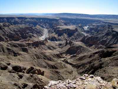 |
Fish River from the Canyon Viewpoint
|
Sunday 23 October
 |
Fish River Canyon near Ai-Ais
|
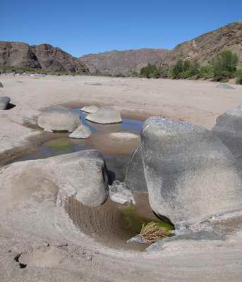
We had a whole day to experience Ai-Ais, and an incredibly hot day it was too. We all set off at 08.00 to walk up the canyon. This was not easy due to the soft wind-blown sand in places, and the boulders in other places. The trail wasn't too clear either, winding through the bushes and then disappearing into a stony wasteland. However, it was a gentle & pleasant stroll, with good views of the tortured rocks of the canyon sides, with streaks of white quartz here and there. After just over an hour & a half we turned back - the temperature was rising. At the turning point the river bed was dotted with rocky pools of water, the rocks having circular tide marks on them, left as the water levels fell. There was some life in the pools - tiny fish - and plenty of green algae growing too.
During the walk we spotted the occasional dassie, lizard, a number of little birds and flowers that mostly were yellow - obviously the colour of the season.
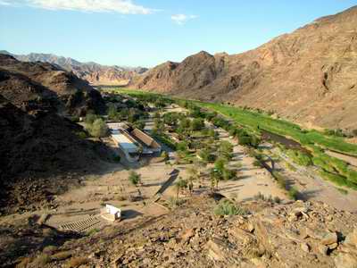
Apart from soaking in the various hot pools that was pretty well the end of anything active for the day - it was too hot to contemplate doing much else. As the sun went down I did climb up the adjacent hill to the cairn on the top to get an overall view of Ai-Ais. The location suddenly made sense - a wider, flatter part of the valley, and a veritable oasis amongst the rusty rocks of the canyon. The resort itself was covered in shadow as the sun had already gone down behind the canyon side. The surrounding rugged peaks looked fantastic, however, in the evening colours.
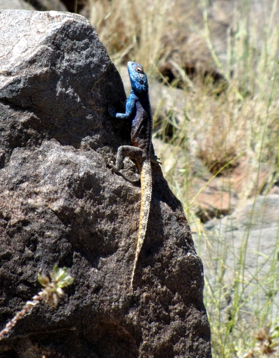 |
Southern Rock Agama |
Monday 24 October
 |
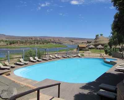
Ai-Ais |
Three of us had an early morning walk up to the cairn on the hill overlooking Ai-Ais, and this time the sun shone down into the canyon, highlighting the greenness of the resort. Unfortunately a number of people were under the weather, due possibly to the heat, or the food. Luckily the next night's stay was only two hours away on the Orange River.
It was with some relief that we arrived at the Felix Unite Cabanas resort on the Orange River with the sick bags still unused!
Not everyone appeared for lunch though, and the number of takers for an afternoon's canoeing on the river dropped below the minimum number required for the trip - just Ben & myself being up for it. Chantel managed to get the lodge to agree to us having a shorter paddle up the river from the lodge & back (instead of being dropped upstream by car & paddling downstream only). We had been warned about the wind beforehand, which in places blew stronger than the current, but mostly meant that if you stopped paddling the canoe stood still. Still, we made it back, and negotiated the little rapids by the cabanas OK despite the audience waiting for us to capsize!
At least we had trialled an alternative method of entering South Africa should there be problems at the border the next day!
 |
Felix Cabanas
|
Tuesday 25 October
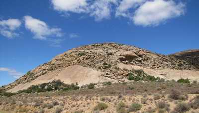 |
Granite hills en route |
Our last border crossing, out of Namibia and into South Africa, passed off smoothly & with little delay. We then climbed out of the Orange valley onto a semi-desert plateau, and for a couple of hours went past countless granite domes with bare slabs of rock emerging from huge bouldery slopes.
We stopped for an hour in Springbok, for shopping & to give Todd a chance to check his fuel filters, as his vehicles was losing power. It was a strange town full of supermarkets and garages. And an interesting book shop.
Then it was another couple of hours driving over the plateau, trying to keep awake, and wondering where all the flowers, for which Namaqualand is famous, had gone (finished at the end of September apparently!). We had a picnic lunch on a dusty lay-by and then carried on, past some impressive escarpments, to Clanwilliam, on the edge of the Cederberg mountains.
We had enough time to explore the one main street of Clanwilliam, home of the Rooibos tea factory. Not a lot was open, but the tourist office gave me directions to the Ramskop wild flower garden on the edge of town, beside the Clanwilliam Reservoir. I decided to go for it and had a short time to go round the sandy tracks on the hillside, passing different habitats and with some plants labelled - including the rooibos shrub itself, looking for all the world like broom.
Back at the hotel we had another large meal - with, as usual, twice as much meat or fish than most of us could eat. We must walk it off a bit sometime....
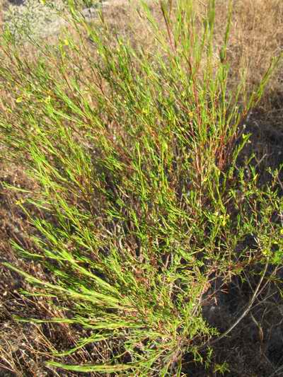 |
| Rooibos, the bush used
for Rooisbos tea |