Peru Diary 8
Oct 19
 With the group gone I had intended to get out of Lima
immediately, but the Sunday buses to Huaraz were fully booked, so I had
to stay an extra day in Lima. Due to a misunderstanding at the hostel I
also ended up having to take a taxi to the Cruz del Sur bus station in
order to buy the ticket - well that filled up some of the spare time!
With the group gone I had intended to get out of Lima
immediately, but the Sunday buses to Huaraz were fully booked, so I had
to stay an extra day in Lima. Due to a misunderstanding at the hostel I
also ended up having to take a taxi to the Cruz del Sur bus station in
order to buy the ticket - well that filled up some of the spare time!
Not wanting to waste the rest of the time I decided to investigate some
more of Lima's pre-history, and walked to the adobe pyramid of Huaca
Huallamarca, dating from AD 200-500.
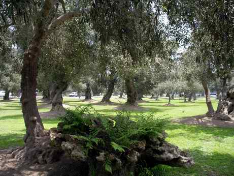
En-route was the district of San Isidro, an area of more up-market
housing and a business district much of which was located on a former
olive grove. Surprisingly much of the olive grove still remains, in the
form of a linear park and gaps between housing plots. The gnarled
trunks of the old olive trees contrast starkly with the variety of
designs of the residential properties , from mock Elizabethan to
modern, scattered round the old grove.
Olive grove in San Isidro
Shhh!
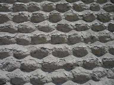 The Huaca
Huallamarca pyramid was constructed of mud 'pebbles', rather than
rectangular bricks, and had been extensively restored - although it
wasn't really obvious which bits were 'new' rather than original.
The view from the top platform was straight into the fourth floor of
the surrounding office and residential blocks. Given the history of
Peru since the pyramid was built I found it remarkable that it has
managed to survive Incas, Conquistadors and property developers !
The Huaca
Huallamarca pyramid was constructed of mud 'pebbles', rather than
rectangular bricks, and had been extensively restored - although it
wasn't really obvious which bits were 'new' rather than original.
The view from the top platform was straight into the fourth floor of
the surrounding office and residential blocks. Given the history of
Peru since the pyramid was built I found it remarkable that it has
managed to survive Incas, Conquistadors and property developers !
Detail of Huaca Huallamarca
construction
Oct 20
 The plan for the next ten
days was to travel to Huaraz, north of Lima and adjacent to the
Cordillera Blanca, do some acclimatisation walks and then a trek - I
fancied the trek from Olleros to Chavin, as it ended up at yet another
interesting pre historic site. The only fixed points, however,
were that I had booked the bus to & from Huaraz and also the first
2 nights in a B&B in Huaraz.
The plan for the next ten
days was to travel to Huaraz, north of Lima and adjacent to the
Cordillera Blanca, do some acclimatisation walks and then a trek - I
fancied the trek from Olleros to Chavin, as it ended up at yet another
interesting pre historic site. The only fixed points, however,
were that I had booked the bus to & from Huaraz and also the first
2 nights in a B&B in Huaraz.
The bus journey in a Cruz del Sur double-decker bus was a pleasure and
an eye-opener - more like a low altitude airline flight than a bus
ride. This impression started with the luggage check-in at the
terminal, and continued with the in-flight movies (including Harry
Potter in Spanish) and the hot lunch on a tray - although I have never
played Bingo on a flight. From the low altitude of the top deck of the
bus (and the low speed due to the holes in the road) I had a great view
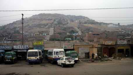
of country north from Lima, starting with miles and miles of
seemingly half-finished brick or adobe dwellings and roadside stores
spreading away from the main road up the slopes of every hill. One area
was jokingly called Shangri-La, before the coastal desert re-asserted
itself and sand and rocks lined the road. Occasional flat farmed areas
(sugar cane, maize and onions), clearly irrigated, broke up the dry
landscape. Now and then on the barren sandy areas there were
lines of huts, resembling army barracks and which turned out to be
'Granjas' or chicken farms.
Lima suburbs from the bus
Eventually the bus turned inland and started climbing. The road surface
deteriorated as the bus wound up through the dry rocky mountains in
valleys reminiscent of Colca Canyon (past peppers drying in the sun)
until we reached the Conococha pass at just over 4,000m altitude and
the landscape opened up - rough Ichu grass in the foreground and
distant glacier-clothed peaks in the far distance. After following the
winding Rio Santa downhill for an hour we arrived in Huaraz, another
town of low brick 'unfinished' houses - no imposing colonial buildings
here, a legacy of earthquakes and landslides. 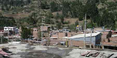 I was met at the bus
station by Maruja, my B&B hostess and shepherded into a taxi to the
suburb of Palmira about 4km north of the centre (or about 60p by taxi
or 14p by collectivo). In the house, another 'unfinished' modern brick
house, I was offered the first of many pots of coca tea that I had
during my stay. I was also offered dinner (chicken) and discovered that
my host, Gilf, was a guide too - so I had not only a source of local
advice on possible walks, but also a source of equipment to borrow -
lucky or what? Outside, the weather reinforced the fact that the rainy
season was just beginning; thunder rattled around the valley and rain
showers obscured the views of the highest peak, Huascaran, which I
should have been able to see from my bedroom window.
I was met at the bus
station by Maruja, my B&B hostess and shepherded into a taxi to the
suburb of Palmira about 4km north of the centre (or about 60p by taxi
or 14p by collectivo). In the house, another 'unfinished' modern brick
house, I was offered the first of many pots of coca tea that I had
during my stay. I was also offered dinner (chicken) and discovered that
my host, Gilf, was a guide too - so I had not only a source of local
advice on possible walks, but also a source of equipment to borrow -
lucky or what? Outside, the weather reinforced the fact that the rainy
season was just beginning; thunder rattled around the valley and rain
showers obscured the views of the highest peak, Huascaran, which I
should have been able to see from my bedroom window.
The
roofs of Palmira
Oct 21
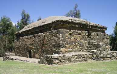 After a discussion with
Gilf, and much poring over maps, I set off on an acclimatisation walk
to the Wari culture burial chambers at Wilkawain (or Wilkahuain), which
was 4km up the hill behind the house. As I set off up the steps at the
end of the street I could now see Huascaran's snowy peak way off in the
distance through the haze. The walk up the hill took me along unmade up
tracks, past single storey mud-brick houses and through fields being
ploughed by oxen, past countless irrigation channels, often with a
woman doing her washing in the rushing water, and past too many yapping
dogs. Despite the total lack of direction signs I found the right paths
and tracks to the impressive 3-storey burial building - Gilf had
explained the route using Google Earth before I set off - yes, even in
deep Peru such technology is employed! I was given a tour round
the building by the site guardian; the building dates from about 1100
AD and on each of the 3 levels there were 7 rooms (the burial
chambers), all constructed from large stones with larger rectangular
slabs forming the ceilings. The top storey was covered with
mud and stones, forming a domed roof. The site lacked any
interpretation, and the museum room appeared to be empty, resulting in
some good practice of my Spanish to ask questions of the guide. I also
got some guidance from him on the route to take to reach a cross I
could see high up on the hill above the site - I didn't feel that I had
properly testing my legs yet!
After a discussion with
Gilf, and much poring over maps, I set off on an acclimatisation walk
to the Wari culture burial chambers at Wilkawain (or Wilkahuain), which
was 4km up the hill behind the house. As I set off up the steps at the
end of the street I could now see Huascaran's snowy peak way off in the
distance through the haze. The walk up the hill took me along unmade up
tracks, past single storey mud-brick houses and through fields being
ploughed by oxen, past countless irrigation channels, often with a
woman doing her washing in the rushing water, and past too many yapping
dogs. Despite the total lack of direction signs I found the right paths
and tracks to the impressive 3-storey burial building - Gilf had
explained the route using Google Earth before I set off - yes, even in
deep Peru such technology is employed! I was given a tour round
the building by the site guardian; the building dates from about 1100
AD and on each of the 3 levels there were 7 rooms (the burial
chambers), all constructed from large stones with larger rectangular
slabs forming the ceilings. The top storey was covered with
mud and stones, forming a domed roof. The site lacked any
interpretation, and the museum room appeared to be empty, resulting in
some good practice of my Spanish to ask questions of the guide. I also
got some guidance from him on the route to take to reach a cross I
could see high up on the hill above the site - I didn't feel that I had
properly testing my legs yet!
Wilkawain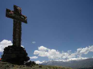
The climb was really worth doing, as the trail rose above the small
fields and farms, and above the straggly eucalyptus trees growing
everywhere, on to more open ground with magnificent views towards the
southern end of the Cordillera Blanca range. The cross, which looked so
substantial from a distance, turned out to be made of wire and straw,
laced with fading flowers. From the cross I struck across country until
I came onto the track which (I hoped) led down to the hot springs at
Monterrey, in the Rio Santa valley about 4km further north from
Palmira. After yet more dogs, irrigation channels, washer-women and
oxen plough teams I reached the rocky crags above Monterrey. It wasn't
very obvious which way to go, and I clearly got the wrong way as I had
my only encounter in my whole stay in Peru with an angry farmer!
Luckily, just minutes before this, an old woman had warned me to pick
up a stick as this farmer's dog was on the rottweiler end of the canine
scale!
I walked back along the road to the B&B, ignoring the persistent
tooting from passing taxis and collectivos. Having been walking for 5
hours, and ascended (& descended!) 680m, and felt OK despite
the altitude, I decided to start my trek the next day - so it was a
quick change and then a collectivo into town to shop for food for the
next 4 days. The town was very busy, with no tourists in sight; despite
the popularity of Huaraz for trekkers, the main season was now over. In
the main street there were plenty of companies offering treks and
tours, but overall the town was the least geared up for tourism that I
had seen so far. The market was crowded with locals & I found most
supplies there - fresh bread, tins of meat, tuna, pasta, risotto,
porridge and bananas. It all felt rather bulky, and my 35 litre
rucksack started to look too small....
The
cross above Wilkawain
Oct 22
Having discussed possible treks with Gilf I changed my plan and decided
to do the Santa Cruz trek, another 4 day trek. The main reason was that
it would probably be safer for me, being alone, if I did a trek where
there were likely to be other trekkers in this out of season period -
the Santa Cruz trek is one of the most popular ones - spectacular views
etc... etc.. This meant an early start, as the setting off point of
Cashapampa was around 3 hours from Huaraz - so breakfast at 05.30 and
off in a collectivo (taxi) into Huaraz at 06.00 in order to squeeze
into another collectivo (minibus) for the 2 hour ride to Caraz. I saw
nothing of the views, as I was squashed in the back with my overflowing
rucksack on my lap - but then the ride only cost £1 (5 soles).
Getting out
of Caraz wasn't so easy. I took a motorbike taxi across 'town' to the
departure point for Cashapampa & sat in a collectivo (taxi) with
one other passenger waiting for others to turn up. After 15 minutes
no-one had, so we decided to share the vehicle as a taxi & paid
£5 each for the winding journey up a dirt track (at times
climbing up a cliff with big drops to one side) to Cashapampa. At least
I think we shared the cost, although I have the feeling that I footed
the whole bill... but then the other passenger was the local doctor
heading for a surgery, so if I did it was in a good cause!
The dirt road just petered out and I was dropped off at a small wooden
hut at the start of the trail. I was invited to pay a 10 soles entrance
fee "to ensure the being of the trails and base camps" according to the
ticket. The trail climbed steeply up the narrow valley of the Santa
Cruz river. Although it was only just past 9am it was already hot and
airless. It wasn't until I had climbed up around 500m that a breeze
helped cool me down a little. Fresh rockfalls had strewn white granite
boulders across the path in places. The number of shrubs and flowers
increased as I got higher; frequent clusters of pink passion flowers
clung to the shrubs.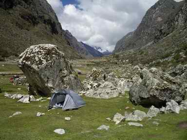
I reached the first designated camp area at Llamacorral much earlier
than I expected after only 4 hours of walking. The site boasted a rough
hut allegedly selling beer and soft drinks - closed of course - and a
toilet block - one of a series that had been constructed along the
trek,
and which were badly in need of repair, despite the fact that they were
basically just 4 holes in the ground with screens and a roof. I suspect
few people used them now, judging by the evidence behind most boulders.
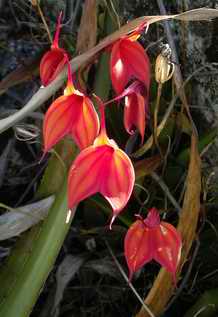
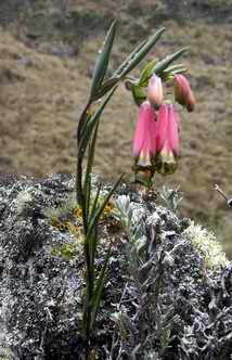
Setting up my tent early gave me plenty of time to explore the rocky
hillsides above the flat meadow area and I was rewarded by finding some
spectacular orchids and watching a number of birds, like flickers and
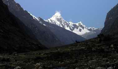
dippers! I didn't realise it at the time, but the afternoon view
up the valley with the snow-capped Nevada Taulliraju silhouetted
against the blue sky was the last time I would see any peaks clearly.
Masdevallia amabilis orchid
First
night's camp site
 The afternoon view up the valley
Given that my wind-up head torch was less than effective I retreated
into my sleeping bag the moment it got dark. By this time I was sharing
the camping area with two trekking groups and their attendant
mules and muleteers - and their private toilet tents.
Oct 23
 It is amazing how long
you remain 'in bed' when camping wild - it was at least 10 hours after
lights out (i.e sun down) that I crept out for a quick breakfast of
porridge and coffee. I set off before 7am, and before the other
trekking groups, so had the trail to myself to enjoy the myriad of
birds flitting around the bushes and the solitary mountain caracara
flying over the ducks and waders on Lago Ichiccocha. The first drops of
rain came a couple of hours later just before the trail forked and
began climbing. I sheltered under one of the extraordinary peeling
Quenual trees and put full waterproofs on. I also dug out the pale blue
plastic poncho that was supplied by the Amazon Lodge during the last
trip, and used this to cover both me and my rucksack. Despite the rain
and low cloud I took the left fork into a side valley off the trail I
had been told that this would give me a good view of the Nevada
Alpamayo - a peak that had been voted the 'best mountain in the world'
by a German climbing magazine sometime in the last century. I got no
view of Alpamayo, but was rewarded by finding a variety of interesting
flowers that I had not seen before - this seemed to happen every time I
strayed off the main trail...
It is amazing how long
you remain 'in bed' when camping wild - it was at least 10 hours after
lights out (i.e sun down) that I crept out for a quick breakfast of
porridge and coffee. I set off before 7am, and before the other
trekking groups, so had the trail to myself to enjoy the myriad of
birds flitting around the bushes and the solitary mountain caracara
flying over the ducks and waders on Lago Ichiccocha. The first drops of
rain came a couple of hours later just before the trail forked and
began climbing. I sheltered under one of the extraordinary peeling
Quenual trees and put full waterproofs on. I also dug out the pale blue
plastic poncho that was supplied by the Amazon Lodge during the last
trip, and used this to cover both me and my rucksack. Despite the rain
and low cloud I took the left fork into a side valley off the trail I
had been told that this would give me a good view of the Nevada
Alpamayo - a peak that had been voted the 'best mountain in the world'
by a German climbing magazine sometime in the last century. I got no
view of Alpamayo, but was rewarded by finding a variety of interesting
flowers that I had not seen before - this seemed to happen every time I
strayed off the main trail...
Milli milli flowers (Bornarea dulcis)
Back on the trail it was not long before I reached the next
overnight camping zone at Taullipampa, below the high pass of Punta
Union - tomorrow's challenge. Another trekking group, going in the
opposite direction , was just setting up camp and I decided to be
anti-social & sought an isolated spot in a bend in the river. On
reflection I thought I had camped too close to the river as it rained
on and off all afternoon and night - but in the event the river didn't
rise very much and I stayed dry. Once again there was a disappointing
amount of litter around - not just the ubiquitous plastic water
bottles, but large cardboard boxes, 2 litre cooking oil bottles, tuna
cans and so on - a clean-up expedition is definitely needed, or better
education or control of the trekking parties.
 I
I
In a gap in the rain I set off to walk up to Lago Taullicocha,
unseen behind a large moraine below the glaciers on Nevada Taulliraju.
I didn't get there - the light was fading but the rain wasn't. I
boiled some water and settled down to asparagus soup, mashed
potato and spam, washed down by coffee, before scribbling some diary
notes as the light finally went, just after 6pm. The rain had
stopped, but none of the surrounding snowy peaks could be seen as the
clouds clung firmly to all the upper slopes.
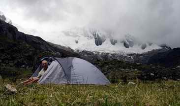
Camping
at Taullipampa, Nevada Taulliraju covered by clouds in the background
Oct 24
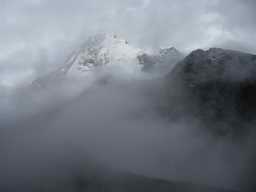 Morning mist around Nevada Artesonraju
I wasn't so enthusiastic about getting up as the light began to get
better - I had had a night of tossing and turning and trying to decided
whether I was cold or not - I was at an altitude of 4,200m after all. A
peep outside the tent, however, revealed a light mist drifting up the
valley with the mountain peaks showing through now and then. So up it
was! I fetched some water to boil for breakfast, but found a gap where
my hired stove should have been. I hunted the area in the vicinity of
the tent - perhaps an animal had knocked it out from under the
fly-sheet - but no sign. STOLEN! Full of puzzled thoughts about
who would steal a camping stove I had a nourishing breakfast of cold
porridge and cold water. As a further test of my spirit the mist
thickened and became laced with rain.
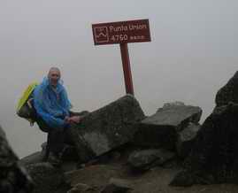 I set off at 7am on
the climb up to the Punta Union pass. The trail zig-zagged up the
mountain and as I climbed the clouds would occasionally part to give a
brief view down the valley. Also as I climbed the rain gradually turned
to snow. When I reached the notch through which the trail passed at
4,760m there were no views - what a let down!
I set off at 7am on
the climb up to the Punta Union pass. The trail zig-zagged up the
mountain and as I climbed the clouds would occasionally part to give a
brief view down the valley. Also as I climbed the rain gradually turned
to snow. When I reached the notch through which the trail passed at
4,760m there were no views - what a let down!
The
Pass
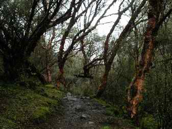 In fact the trail on the
far side was difficult to follow as, unlike the constructed path I had
ascended, it snaked across sloping bare rock marked only by an
intermittent line of boulders on either side. I had no idea where the
path was leading as it disappeared into the mist a few hundred yards
beyond me. I got an inkling of the beauty that must have been around me
from the small lakes and the bases of waterfalls and glaciers that
appeared now and then. It was a couple of hours before the trail
reached the valley bottom and the mist dispersed, to be replaced by
faint sun and frequent showers. By this time the tundra-like vegetation
at the top of the pass had been replaced by scattered woodland of
Quenual trees, their red bark peeling as if with a particularly
virulent disease. Had the sun been out the colour of the bark would
have been striking, as even in the damp gloom it stood out. It was
refreshing to see a native tree species, as most of Peru's cultivated
land has been planted with eucalyptus species. Less refreshing was the
muddiness of the trail through these woodlands.....
In fact the trail on the
far side was difficult to follow as, unlike the constructed path I had
ascended, it snaked across sloping bare rock marked only by an
intermittent line of boulders on either side. I had no idea where the
path was leading as it disappeared into the mist a few hundred yards
beyond me. I got an inkling of the beauty that must have been around me
from the small lakes and the bases of waterfalls and glaciers that
appeared now and then. It was a couple of hours before the trail
reached the valley bottom and the mist dispersed, to be replaced by
faint sun and frequent showers. By this time the tundra-like vegetation
at the top of the pass had been replaced by scattered woodland of
Quenual trees, their red bark peeling as if with a particularly
virulent disease. Had the sun been out the colour of the bark would
have been striking, as even in the damp gloom it stood out. It was
refreshing to see a native tree species, as most of Peru's cultivated
land has been planted with eucalyptus species. Less refreshing was the
muddiness of the trail through these woodlands.....
Quenual woodland
I reached the Huaripampa camping area just after 2pm. It was a flat
grassy area in a wider stretch of the valley, and as a result of the
rain featured a large number of shallow pools! I found a dry spot
behind a boulder and even managed to get the tent up in the dry - and
it stayed that way for almost an hour before the rain started again.
 Luckily in my shopping I
hadn't just bought things that needed to be cooked - I still had some
bread rolls, a tin of tuna, lots of porridge and a banana! For warm
food or a hot drink I had banked on there being another group on the
site from whom I could borrow some heat - but the only people I saw the
whole day were heading up the valley, presumably on the first stage of
their trek in the opposite direction. So I spent the night alone
on my puddle-filled plain, warm as I had now descended to 3,600m (and I
kept all my clothes on), and peaceful.
Luckily in my shopping I
hadn't just bought things that needed to be cooked - I still had some
bread rolls, a tin of tuna, lots of porridge and a banana! For warm
food or a hot drink I had banked on there being another group on the
site from whom I could borrow some heat - but the only people I saw the
whole day were heading up the valley, presumably on the first stage of
their trek in the opposite direction. So I spent the night alone
on my puddle-filled plain, warm as I had now descended to 3,600m (and I
kept all my clothes on), and peaceful.
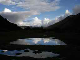
Puddle-valley
camp site
Oct 25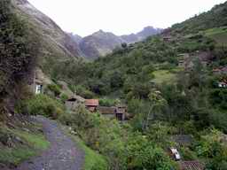
It was so quiet and warm that I overslept (i.e. missed dawn) and didn't
wake until 6am! I had my cold breakfast & then paid a visit to the
horrible toilet structure at the far end of the site. I set off
after packing up my soggy tent and only ten minutes and one flock of
sheep later I reached the first fields and mud-walled houses occupying
the lower valley slopes. Apart from one bizarre Spanish-style modern
building that advertised itself as a hostel the houses were all small
with thatched roofs and one open side. Smoke rose through the thatch
from some of these dwellings, and children began to appear on the muddy
track, begging for sweets. I eventually reached a building with a small
shop that also housed the national Park warden, and had to cough up the
65 soles (£13) Park fee - which obviously doesn't go into upkeep
of the toilets!
The lower Huaripampa valley
I had been advised to get to the road at the end of the trail at
Vaqueria by 11am as after that time I was less likely to find any taxis
or collectivos passing. I reached the road at about 9am & a taxi
drove past as I stepped onto the road. It didn't stop, and no other
vehicles passed in either direction for the next hour. I began to worry
about out-of-season travelling. The village itself, just a few houses
either side of the muddy road, was very quiet - the 2 shops and
café were all closed - apart from the children playing by the
roadside. Down the valley there was a constant flow of sheep, cows and
goats being herded in different directions.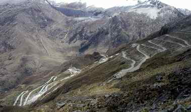
Eventually lorries and the odd bus began to appear - going in the wrong
direction. At last a battered Toyota came in the right direction, which
stopped when I hailed it. I didn't realise until I left the car a
couple of hours later that it wasn't a taxi at all - it was just
someone on his way to visit friends near my destination of Huaraz! I
think I paid 20 soles (£4), including a tip, for this 2 hour
journey. I think this part of the trip was the most dangerous, crossing
a pass that was 7m higher than the one I had walked over and descending
on an exceedingly tight set of zig-zags on a rough track. This would
prove challenging to Chelsea tractor owners, let alone to this owner of
a battered Toyota saloon with worn-out shock absorbers! Halfway down a
set of crosses marked the spot where a bus went over the edge. Although
the tops of the mountains were still shrouded in mist the glaciers on
their slopes were visible beneath the clouds, a truly spectacular area.
It was with some relief, for me and probably the driver too, when we
reached the bottom of the hairpins and reached the day-tourist area of
Lago Llanganuco, although this did mean a large amount of bus traffic
climbing up the road, which was still a rough track and steep, towards
us. Eventually we reached the town of Yungay (and a metalled road) in
the main Rio Santo valley - a descent of over 2,250m in 20km.
The
descent from the Portachuelo de Llanganuco
I was dropped of about 15km from Hauraz and I immediately picked up a
collectivo back to my B&B. Here I had to own up to the loss of the
stove they had lent me...
Despite this, and seeing the hungry look in my eyes after 2 days of
cold food, they invited me to join them for lunch - a superb fish,
mussel and vegetable soup followed by one of Peru's national dishes -
Ceviche. This is raw fish and shell fish 'cooked' in lime juice spiced
up with onions and peppers. Served with potatoes and sweet potato it
was out of this world! This late lunch ended just as thunderstorms were
beginning to crash around Huaraz, ending any thoughts of going into
town in the afternoon or evening.
Oct 26
 I had two more days in
Huaraz before I had to return to Lima and home, and Gilf suggested that
I accompanied him today to watch his local football team, Ancash play
Universitario. As this wasn't until lunchtime I decided to spend the
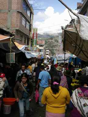
morning wandering around the town. It was Sunday, so I thought it would
be quiet. Wrong! The whole of the quarter to the north-west of
the centre was packed - each street was filled with market stalls
selling everything from fruit and veg, meat and fish, to clothes and
household items, live guinea pigs and chickens. This was the market for
locals - the craft market with Peruvian hand-made items was near
the half-finished Cathedral, and empty. I stopped in a
café for a 'café con leche', and was served with a glass
of hot milk and a small jug of cold expresso coffee - that's a new
version to me!
I had two more days in
Huaraz before I had to return to Lima and home, and Gilf suggested that
I accompanied him today to watch his local football team, Ancash play
Universitario. As this wasn't until lunchtime I decided to spend the
morning wandering around the town. It was Sunday, so I thought it would
be quiet. Wrong! The whole of the quarter to the north-west of
the centre was packed - each street was filled with market stalls
selling everything from fruit and veg, meat and fish, to clothes and
household items, live guinea pigs and chickens. This was the market for
locals - the craft market with Peruvian hand-made items was near
the half-finished Cathedral, and empty. I stopped in a
café for a 'café con leche', and was served with a glass
of hot milk and a small jug of cold expresso coffee - that's a new
version to me!
One of the market streets
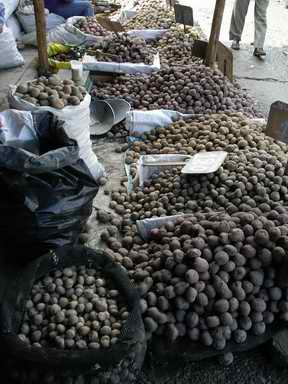
Dozens
of potato varieties on sale
By the time Gilf & I headed for the stadium the sun had come out,
and the vendors in the stadium were doing a brisk trade in sun visors,
green Ancash caps, and ice cream. Trays of food were also being sold -
mainly ceviche or chicken; not a minute went by without another vendor,
aged from about 7 to 70, passing along the terraces. Plastic sheets
were also being sold - but they didn't sell very well until towards the
end of the game when the thunder started and the rain came - the macs
and plastic stopped the rain from wetting our tops, but couldn't stop
the water flowing down the concrete terraces and soaking our trousers.
Damp bums were very much in evidence as the crowd dispersed after the
rather pedestrian game which Ancash (fortunately) won 3-0. The crowd
was very vocal, there was much drumming, but it was a well behaved
crowd and there were plenty of families. No chances were taken,
however: I noticed that the referee was escorted off the pitch by the
police!
Oct 27
 On Gilf's advice I decided
to walk to Laguna Churup, a classic acclimatisation walk close to
Huaraz. This involved a collectivo or taxi ride up to Llupa to the
start of the walk - this is where I found that I hadn't yet managed to
distinguish when a taxi was operating as a taxi i.e. you pay for the
whole trip yourself, or when it is operating as a collectivo and
charges a set, lower, fare and will pick up other passengers en route.
I stopped a taxi, and it was only when I noticed that it wasn't hooting
at every junction and didn't stop for the people waving their arms at
it, that I realised it was operating as a taxi - so I paid as much for
this short 20 minute journey as I paid for the 2 hours ride across the
mountains. Never mind, I got quickly to the start of the trail along
the very muddy 'road' from Huaraz. The driver indicated the track I
should take, and it wasn't until about an hour later that I finally
managed to make sense of the many paths marked on the map and confirm
that I was on the right trail. I had to show my National Park receipt
to the lonely official on the start of the path at the non-existent
settlement of Pitec, then the path climbed steeply up a lateral moraine
to the foot of a waterfall tumbling from lake high above. This section
of the path was made more exciting by the rain, now falling, making the
rocks wet and potentially slippery. It was therefore a careful, but
straightforward, scramble up. The descent on the other side of the
waterfall wasn't quite so simple, and at one point involved dangling a
foot over an edge to hunt for the top rung of a very rustic wooden
ladder, whilst holding on to the rock with a very skimpy
handhold.
On Gilf's advice I decided
to walk to Laguna Churup, a classic acclimatisation walk close to
Huaraz. This involved a collectivo or taxi ride up to Llupa to the
start of the walk - this is where I found that I hadn't yet managed to
distinguish when a taxi was operating as a taxi i.e. you pay for the
whole trip yourself, or when it is operating as a collectivo and
charges a set, lower, fare and will pick up other passengers en route.
I stopped a taxi, and it was only when I noticed that it wasn't hooting
at every junction and didn't stop for the people waving their arms at
it, that I realised it was operating as a taxi - so I paid as much for
this short 20 minute journey as I paid for the 2 hours ride across the
mountains. Never mind, I got quickly to the start of the trail along
the very muddy 'road' from Huaraz. The driver indicated the track I
should take, and it wasn't until about an hour later that I finally
managed to make sense of the many paths marked on the map and confirm
that I was on the right trail. I had to show my National Park receipt
to the lonely official on the start of the path at the non-existent
settlement of Pitec, then the path climbed steeply up a lateral moraine
to the foot of a waterfall tumbling from lake high above. This section
of the path was made more exciting by the rain, now falling, making the
rocks wet and potentially slippery. It was therefore a careful, but
straightforward, scramble up. The descent on the other side of the
waterfall wasn't quite so simple, and at one point involved dangling a
foot over an edge to hunt for the top rung of a very rustic wooden
ladder, whilst holding on to the rock with a very skimpy
handhold.
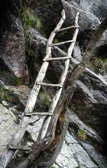
The rain held off when I reached the beautiful lake nestled in the
rocky corrie, but the cloud never lifted enough to reveal the peaks
above the lake. As I came back down, however, a huge thunderstorm was
passing over towards Huaraz. Only the fringe passed overhead,
sprinkling me with rain again, but leaving behind it a beautifully
clear sky - and suddenly all the snowy peaks of the Cordillera Blanca
towards the south - Nevadas Huamashraju, Cashan and Shacsha - were
visible.
The rustic ladder
Forgetting that the scale of my map was 1:100,000 I decided to walk
directly back to Palmiras rather than returning to my drop off point at
Llupa. I started on a small trod which branched off from the path at
the top of the moraine, but was soon heading off through the rough
grass and boulders to contour around the hillside to meet a track that
would lead me back. If the shepherdess I met en route was surprised,
she didn't show it, she just asked me if I could tell her the time.
When I hit the track I was surprised to find the figure of 19 km
painted on a rock - usually this means the distance to the start of the
road, which in this case would be Huaraz. Did that really mean I still
had 19 km to walk? Perhaps the distance was in the opposite direction.
Unfortunately after walking just a little way along the dirt road I saw
18k 850m painted on a rock.... OK so I still had a long way to walk! I
sped up, trying to ensure that I walked each kilometre in less
than 10 minutes. Which, by taking short cuts as often as possible when
the road dropped downhill in zig-zags, I achieved, until I reached a
sign "Wilkawain". This was rather odd, as I had visited it a week ago,
but this looked different! Speaking to the person at the gate I
discovered that this was Ichu Wilkawain, a sort of smaller sibling of
the one I had visited before, which was another 500m along the road.
Astonishing! there was no clue at the other site that there was a
second one nearby - and a second one that had information panels in
both Castillian and English. I visited the site, and my average speed
dropped accordingly.
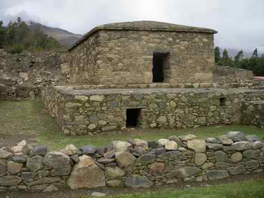
Ichu
Wilkawain
When I had toured the site, which had a number of separate burial
buildings and dwelling areas, the warden indicated a small path which
he said would lead me down to Palmiras. This lovely path, partly paved,
followed alongside an irrigation channel. the only problems came when
both the path and the water channel branched. The map clearly showed
none of these! However, with a bit of luck, a good sense of direction,
and one helpful child I ended up on a road I recognised, and retraced
my route of the other week back to my B&B.
Oct 28-29
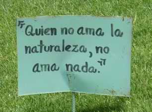 Waiting for the bus back to
Lima I wandered around the main square in Huaraz, taking in the
philosophical sayings planted on each of the grass areas: "Life
without plants is not life at all" and so on.
Waiting for the bus back to
Lima I wandered around the main square in Huaraz, taking in the
philosophical sayings planted on each of the grass areas: "Life
without plants is not life at all" and so on.
Then 8 hours, 3 films, 2
music videos but no bingo, later I arrived in Lima. There was time to
pack, to have a last 'national' dinner of Ceviche with a Pisco Sour
cocktail, to wander to Larcomar for a last look at the Pacific and to
have a cheap 3-course menu lunch for 9 soles. After a final taxi ride,
taking yet another different route to the airport, I headed home......
Hauraz grass-root philosophy
Back to Peru Trip Index